
Whenever I’m writing a secondary world, I always draw a map. Even when I don’t need to—even when the characters aren’t going to be traveling all over that beautiful map I drew. I imagine for some writers they aren’t important. It’s enough to know the distance between certain locations, and the names of the different countries, and that’s it. But I feel like I can’t start without knowing the shape of the world. I often don’t begin to do any world-building before drawing the map.
Part of it is this idea that I don’t know what I’ll need until I get there—I don’t know if I’ll need to know the topography of a certain part of the world until I’m in the middle of the first draft, and a character needs to have an anecdote about it. If I come across that situation, I’d rather be able to pull from an independent document rather than make something up on the spot (though I certainly have done that.)
Last week I talked about my personal process for drawing maps. This week, I’m writing about how all the information that I put into my maps helps me with world-building, characters, and plotting. While everything I’m going to talk about can be accomplished through written world-building, I find that maps do a lot of the same stuff much better and more efficiently than written descriptions. So, here are the four aspects of world-building and plotting for which I rely greatly on maps.
Economy
The economy of a country is very important. The largest industries of a nation, or the biggest export, may be the defining feature of the state—like Saudi Arabia and oil. It could also be an easy way to fill in a character’s backstory—if they come from a country renowned for trade, perhaps they spent most of their life working as a merchant. Maps inform economy in a few ways.
Below is a map of the Arch, a world I used for the trilogy/serial Mr. Anyone, which should illustrate the point pretty well.
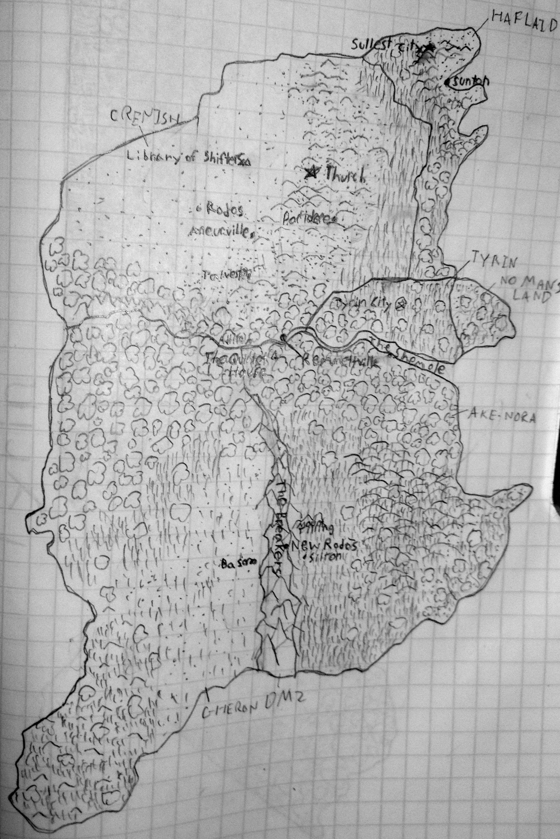
What I look at most to determine economy is terrain. Ake-Nora (bottom right) is full of plains. It is the bread basket of the world. So most of the Ake-Noran towns that appear in Mr. Anyone are small farming communities.
With Crenish (top left), I have a decision to make. The region is mostly desert. It could be a sparsely populated wasteland, with little economy to speak of except in the forest and plains regions. Or it could be rich in some resource (salt, oil, gold), and the wealthiest nation of the world. Because I wanted a balanced world, I went with the latter—the hills of Crenish are full of metals and nitrate. Crenish is the industrial power of the world.
Haflaid (top right) presented another choice, like Crenish. It’s a small state with diverse terrain, but there is one aspect of it that is consistent throughout. It’s all coastal. So I decided Haflaid’s economy would be based on trade and tourism. By having it drawn out, and seeing how it’s stretched out along the coast like the Florida panhandle or the, I was able to easily make that decision.
Culture
Terrain is also useful in determining culture. An island nation will have a great deal of lore associated with the sea. A civilization based in flood plains may imagine a fertility god as the ruler of the world. As well, terrain determines cuisine, which is both an important part of a civilization’s culture, and an excellent, visceral way for a writer to portray a distinction in societal customs.
This is the map that I used in last week’s post.

It’s worth noting that the larger empires will probably have a very muddled national identity. Look at the one in the middle, for example. The culture of the people living in the north will be completely different from those living in the far south. The same might be true for the country directly south of the empire, but the terrain is all homogenous, and a monolithic culture based on the jungle, which dominates that land, may actually be plausible.
Equally, several small states in the same area will probably have very similar cultures, all of them being in close contact with one another, and all of them sharing a similar topographical basis for their civilizations.
Speaking of contact, that’s another thing maps can display very easily—how isolated is a country, or region? The southern landmass has only a narrow land connection with the northern landmass, so it will probably have quite a few fundamental differences in culture—perhaps a different alphabet, or a different family of sports which are popular there. However, the two are not completely isolated, so there will be some similarities, especially in the isthmus connecting them, and the sea between them.
Obstacles
Up until now I’ve been talking about how maps inform decisions in world-building. And while world-building does affect plotting, this is a way that maps can directly affect a story, by complicating it. Geographical features provide excellent obstacles for characters to overcome, which make for engrossing stories—like Hannibal crossing the Alps.
Below is a map for the novel I wrote for NaNoWriMo.
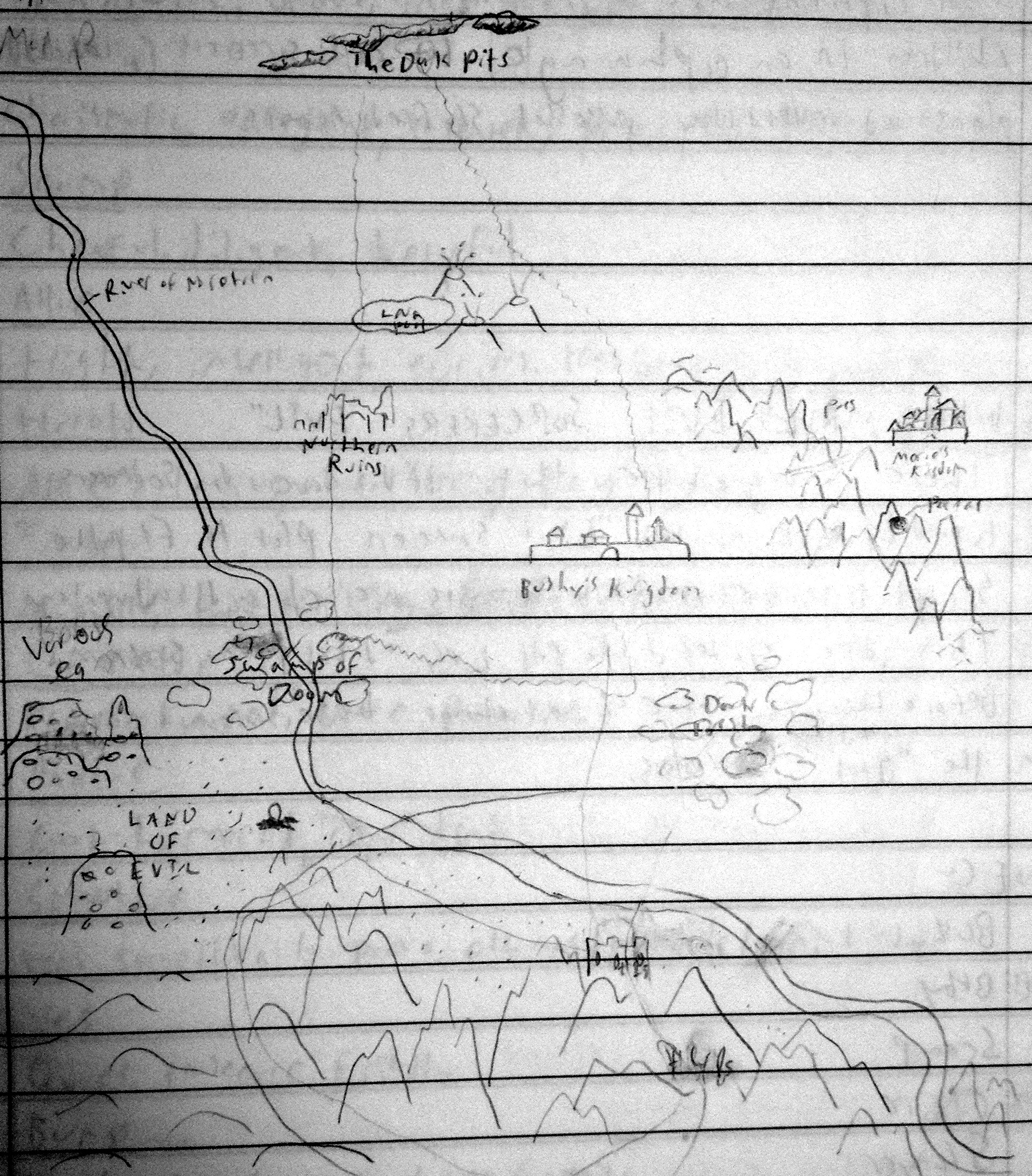
This is a much more zoomed in map than any of the others, but it’s useful for this particular aspect. Before I started writing this book, I drew this map. Some of the landmarks on the map are never even mentioned in the story—but they’re there if I need them. If a path had gone through the northern ruins, I would’ve had a set-piece ready and waiting for that story.
These obstacles also tell me the defensibility of a location, which is particularly useful if a story involves some type of battle or war (and my stories very often do). Obstacles reveal the path of least resistance—the likely route for an invasion. For Morrie’s Kingdom (upper right), it would be through the mountain pass (the mountains being the obstacles, in thsi case.) But obstacles can also provide a nice twist—if an army finds a clever way to approach through an obstacle thought to be uncrossable, this can throw a wrench into things, and change the dynamics of the battle in an interesting way.
Power
This is probably the most important bit of information that maps provide, at least for me. Stories are about conflict, and power (the amount and the type of it) determines how that conflict can be resolved.
This is a map of the Breath, a world I used for an untitled short novel, and which I will probably return to at some point.
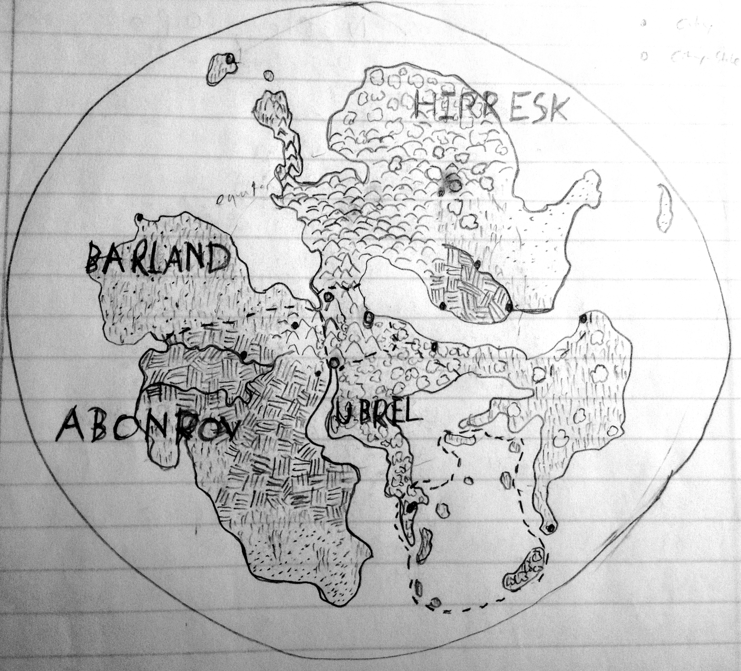
The easiest way to translate a map into an abstract concept of power is by size. Big country = powerful country. Small country = weak country. For the Breath, this is mostly true. Hirresk and Abonrov are the major powers of the world. However, their powers are different, based on economy (based on terrain.) Abonrov’s power lies in its people, while Hirresk’s power lies in its production capabilities. This has a lot of implications, one of them being the way they use magic. Hirresk enslaves their sorcerers, forcing them to use their powers in factories. In Abonrov, sorcerers are respected community leaders, and use their powers to increase crop yields. Because of their differing terrains, Abonrov is poor in resources, and so their military depends heavily on sorcerers. By contrast, the military of Hirresk, which my map tells me is full of hills and mountains and forests, is founded on well equipped, well armored, non-magic combatants.
And what about the little country at the center? Those are the city-states. They hold a different kind of power, not based on resources or on size, but based on the geography of the map. They possess centrality. Messages, caravans, and immigrants (at least ones traveling by land) must run through them if they’re moving from one major landmass to another. This tells me that while these cities don’t possess much in the way of raw military or economic power, they can justify their existence by wielding a great deal of diplomatic power.
So, those are the aspects of writing for which I find maps are most useful. There are probably more I can’t think of, but these are the big ones.
While all of these decisions could be made without anything being drawn out, I still prefer to use maps. Maps impose boundaries. Obviously they impose political boundaries, but they also impose boundaries on what I can and can’t write. If a city is located in a polar region, I can’t write about how everyone there grows bananas. This forces me to make more consistent, controlled decisions, rather than being able to roam freely. By deciding terrain and coastline and political boundaries beforehand, I lock the world down as a concrete place that doesn’t just bend to the needs of the story.
For all the time and effort they take to draw, to map, when it comes time to write, using maps actually makes stories feel less planned and stilted, and more natural and explorable.
