
I write a lot of secondary worlds, so I draw a lot of maps. Some are fairly simple, some are more detailed. The more detailed ones are for worlds that I’ll have to write in for awhile—novel- or novella-length pieces. In this post, I’ll go through my process for making one of these most detailed maps, because the process for less detailed maps is essentially the same, but with only the specific aspects I need.
This post isn’t meant to be a how-to—it’s just my own system that I’ve developed and modified as I’ve been drawing maps for invented worlds since I was ten. There are a thousand ways to go about map making (one of those thousand being to not make a map at all), and this is just one of them. I’m sharing it because I think it’s interesting, and I haven’t read much from other writers about this part of the creative process. Hopefully it is at least entertaining, and at most it provides some useful tools for fellow writers to improve their world-building.
So, let’s begin.
Given Information
The first step isn’t really a step, but it is important. When I’m drawing a map, I’m drawing it for a specific story, or story idea, so I’m not totally improvising. I draw the map with the knowledge that it will have to work for a specific world—though how specific varies. Sometimes I just know that the setting will be a mid-sized medieval state. Other times the story demands a more specific world, with multiple nations with specific relationships with one another. A story about a naval adventure is going to inspire a different map than a story about a deadlocked war.
For the example map that I’m drawing for this post (and possibly for a book, or a play, or nothing else, we’ll see), I started with the idea of a decaying medieval empire.
Now, the real first step.
Coastline
I begin by drawing the coastline of the world. Every other detail I add will be informed by the physical shape and location of the land mass(es), so this is what I start with. This one is fairly detailed, though it doesn’t have to be. I just think it looks prettier when its all squiggly.

When drawing the coastline, I don’t have a big picture in mind right from the start. I just wiggle and zig-zag randomly, and slowly I start to get an idea in my head of what it will look like when it’s done. I’ll sometimes consciously decide to draw a certain feature, like a bay or a peninsula, but for long stretches I’m basically doodling. If I see an opportunity to change the shape of the world in an interesting way, like that isthmus, I will.
By “interesting” I mean “relevant to the formation of civilizations.” Coastline informs the ability of nations, cities, and tribes to interact with one another, and for a large story I want a large variety of possible interactions. A small island can be isolating. A large bay can be a nexus of cultural and economic exchange. An isthmus can be a choke point, or a site for a canal. These are the semi-conscious ideas running through my head as I draw. I may never include any of these backstories in the actual story, but they’re there if I need them.
Geological Features
Next I draw rivers, mountains, and lakes. Again, these will inform the next steps in the process, and again, I’m mostly doodling. I take some inspiration from the Earth (as I do for all the different steps, not just this one), because it’s the only real world to take inspiration from, but it’s mostly just random subconscious impulses guiding me.

I made sure to keep a big area of open terrain in the middle of the northern subcontinent—at this point I knew that was where my empire would be. Mountains, rivers, and lakes often serve as borders between nations, so if I had a more specific, complicated idea about the world I wanted, I’d be drawing everything out with more thought. As it is, I knew I just needed a large, easily controlled area, so I left some blank space in the middle and then doodled randomly elsewhere.
I also did some shading around the coastlines to make them stand out clearer, and to better show areas with heavy marine traffic.
Biomes
With water sources and mountains in place, biomes are easier to figure out. Knowing the location of the equator is important too (as long as the world has an equator. That’s not a given in fantasy worlds.)
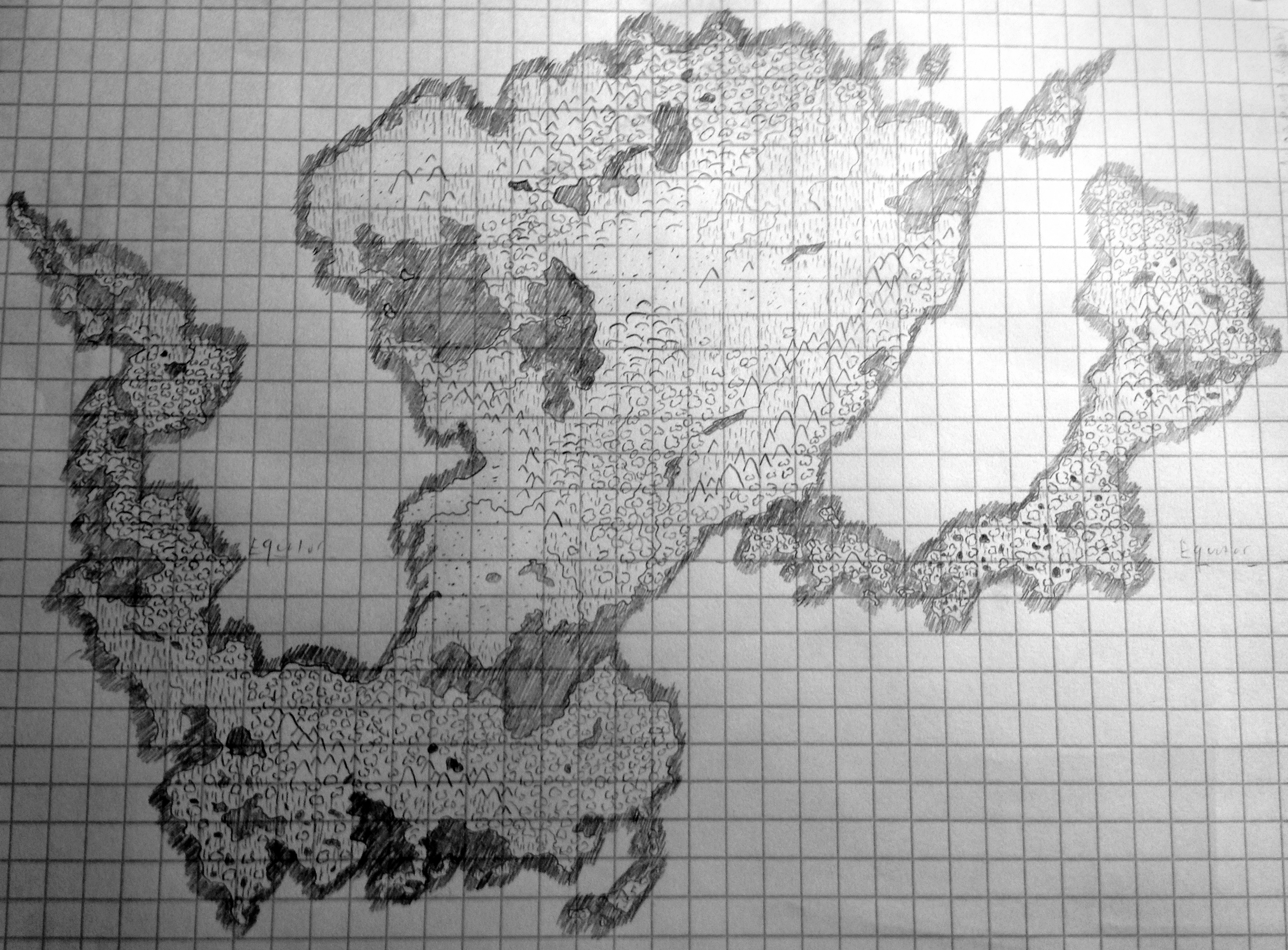
Biomes are important because they determine economy and mobility. I didn’t have any specific economy in mind for my decaying empire, but I did want it to occupy an area of land that could be quickly conquered, and slowly lost. Thus, desert and plains, and some forest.
When I draw maps, I draw deserts (the little dots), plains (horizontal lines), and forest/jungle (the fluffy popcorn things. I’ve been using this visual code for so long that it instantly registers as forest to me, but maybe they look like dustbunnies. Whatever.) And I can draw out different biomes by combining these. The plains/forest/small lakes areas are swamps. Areas with a few trees scattered throughout plains are savannah. There are many more kinds of biomes than this, but for this big, zoomed out map, these three basics are really all I need.
Political Boundaries
Finally, the political boundaries. This is the point where I really start to build off of all the information I’ve already laid out. Rivers, mountains, differing environments, and coastlines all help me decide how to draw out the nations. This is the most thoughtful part of the process, with very little improvisation—especially if I have a more detailed world in mind.

I started putting down cities and capitals too, but I stopped after I’d drawn all the ones near the empire. I find it useful to know where capitals are, but other random cities I can practically place anywhere. This is the point where I stop drawing the map to inform the story, and start having the story inform the map. Anything else I draw on it will be dictated by the story, and will mostly be to help me keep track of things—Where is the hometown of one character in relation to another? What path is a group taking to arrive at a mountain? What part of the forest do the Mu’traklat’nek live in?
Of course, I’m still pulling from the map to inspire my world-building, I’m just not adding any new inspiring information to it.
And that’s how I make a world. Next week I’ll post about how exactly the maps that I draw inspire my writing, from world-building to plotting—how a world makes a story.
